 |
 |
||
|
||||
|


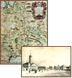
A geographical map is an exact F. Kluwer Old geographical maps let us judge about other times and cultures. They are a combination of historical background, political interests, scientific knowledge and world outlook of the time. In one of his poems Alexandr Blok wrote that ‘if you find a speck of dust from the other country on your pocket knife, the world seems strange and unfamiliar’. Engraved maps are both exact and beautiful being a combination of art and mathematical principles. For this exhibition we have chosen maps which were made by famous engravers or taken from unique editions. The collection includes Muscovy’s maps which reflect historical events of the past. The first printed maps were xylographical. Of course they were not as exact and colorful as those drawn by hand in medieval times but they were printed in a large number of copies and thus available for everyone. Till the end of the 19th century (for almost 300 years) maps were engraved on metal plates. They were engraved by famous masters and printed in well-known European publishing houses and thus can be considered masterpieces of art. Old Muscovy’s maps show that Western Europe was very interested in the mysterious state which lay east of the civilized world at the time of Ivan III. European sovereigns tried to conclude an alliance with Muscovy to struggle against the immemorial enemy – the Ottoman Empire. Enterprising merchants, Dutchmen and Englishmen looked for the way to enigmatic China, Persia and other Asian countries. Scientists tried to solve centuries-old geographical mysteries known since the times of Aristotle and Ptolemy concerning the shape of the Caspian Sea and the flow of the Syr Darya river, as well as the strait between Asia and America. The collection exhibited at “The New Hermitage I” art gallery illustrates all those points. In the late 16th – early 17th centuries courageous Dutch seamen under the command of W.Barents searched for the Northeast Passage to China but were tramped in ice not far from Novaya Zemlya. The maps taken from M. Bellin’s “Descriptions of Voyages” give much information concerning the attempts Europeans made to reach China via the northern route. At the time of Ivan the Terrible English travellers (the most famous of them was A. Jenkinson) came to Muscovy via Arkhangelsk. Their interest in the Russian North – the land of furs and sea animals – is reflected in the maps of 17th—18th centuries. It should be mentioned that since the time of the famous cartographer Mercator it has become a tradition to draw maps using a Mercator projection. On a Mercator projection the landmass of Polar Regions appears to be greater than that on modern maps. It is thanks to Mercator that collections of maps are called “Atlases”, because he drew the antique giant Atlas supporting the world on the front page of his maps. Another important political, historical and thus geo- and cartographical problem was the Ottoman Empire or the immemorial “question of the East” as politicians of the 19th century used to call it. Taking into consideration that in 1683 Turkish troops were near Vienna – right in the center of Europe – an alliance with Muscovy and an exact map of its Southern borders was very important. That is why a large number of maps show the Black Sea and the Sea of Azov as well as the disappearance of Tatar khanates in the Southern steppes when they receded beyond Perekop and the Crimea became part of the Russian Empire. In the late 17th century Johann Batiste Homman (1663—1724) began manufacturing maps in Germany (by the time for about 100 years the best maps were considered those made in Holland). Homman set up a typography in Nurnberg to publish geographical literature and the business flourished. Most of the exhibited maps belonged to the “Large Atlas of the World” (1716, 126 sheets) and were printed by Homman’s heirs after his death. During the 17th century in Europe there were re-published Hessel Herrits and Isaak Massa’s maps. However since 1674 the majority of maps in Russia were French. The first map of the kind was made by Sancon and till the 18th century it was re-published under other names. French cartography traditions were based on the scientific researches of the Parisian Observatory which was considered an authority by the Royal Academy of Sciences. The brilliant epoch of French science and culture during the Enlightenment influenced other countries including Russia. As a result Russian maps and atlases were usually printed in the French language. The second part of the collection consists of lithographs printed from the sketches of the French traveller André Duran who travelled across the European Russia in the late 30s of the 19th century. Although most of the European travellers of the early 19th century like marquise de Kustrin or Joseph de Mestre took a negative attitude towards Russia, Duran’s lithographs show a flourishing country with rich peasants living in two-storied houses which resembled estates. Even taverns in his landscapes look like fairy chambers. Thus the exhibition shows the evolution of the image of Russia-Muscovy in the European mind as well as the attempts to depict on paper the whole world of principalities and regions, the world that served as the bridge between Europe and Asia. Piggot G.S. |
|
||||||||||||||||||||||||||||