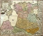
The map of the principalities of Livonia and Kurland with the corresponding islands.
Germany, Nurnberg. 17th century.
Copperplate engraving, watercolor.
Rag paper.
Off-print: 49.5 x 59 cm.
Sheet: 54 x 62 cm.
Compiler: J. B. Homman (geog
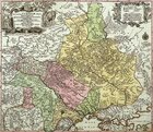
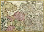
The map of the Kingdom of Ukraine with the palatinates of Kiev and Bratslavsk.
Germany. 17th century.
Copperplate engraving, watercolor.
Rag paper.
Off-print: 50 x 58 cm.
Sheet: 55 x 62 cm.
Compiler: Sutter Mathias (geographer of His Ro
The map of the southern part of Muscovy.
Holland, Amsterdam. 17th century.
Copperplate engraving, watercolor.
Rag paper.
Off-print: 42 x 56 cm.
Sheet: 52 x 66 cm.
Compiler: de Lill
Publishers: R. and J. Otten
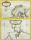
The map of the part of the Arctic Ocean including the New Land and the Samoyed coast.
The map of the strait of Vaygach or Nassau.
France, Paris. 1758.
Copperplate engraving, watercolor.
Paper vergé.
Off-print: 23 x 37 cm.
Sheet: 24.5 x
The new map of Muscovy. Northern part.
Holland, Amsterdam. Early 18th century.
Copperplate engraving, watercolor.
Rag paper.
Off-print: 42 x 56 cm.
Sheet: 52 x 63 cm.
Compilers: R. and J. Otten
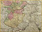
The map of Ukraine and the Cossack Land including Vlachia, Moldavia, Malaya Tatariya.
Germany, Nurnberg. 17th century.
Copperplate engraving, watercolor.
Rag paper.
Off-print: 49.5 x 59 cm.
Sheet: 53.5 x 61.5 cm.
Compiler: J. B. Homman
1
|
2
|
3
| 4 |
5
|
6
|
7
|
8
|
9
Here you can order catalogue of exhibition
"
Maps and views of Russia. The exhibition of engravings and lithographs. 17th—19th centuries.
"
order catalogue
Great talent and unhappy life
>>>
Exhibition "A.P.Chekhov and the town of Voskresensk" in "New Jerusalem"
>>>
Enter your e-mail to subscribe to our news posting
Name
e-mail address
About the New Hermitage
|
News
|
Gallery's collections
|
Exhibitions in the New Hermitage
|
Publishing department
|
Library of images
|
Services of gallery
| |
Ďî-đóńńęč
© 2001 The New Hermitage
Design and support:
positive
media