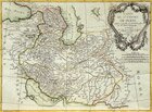
The map of the Persian Empire.
France, Paris. 1787.
Copperplate engraving, watercolor.
Rag paper.
Off-print: 33 x 44 cm.
Sheet: 37 x 51.5 cm.
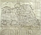
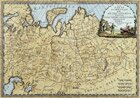
The map of the Russian Empire and Tatariya.
Germany, Nurnberg. 1739.
Copperplate engraving, watercolor.
Rag paper.
Off-print: 49 x 57 cm.
Sheet: 50 x 59 cm.
Compiler: J. M. Haff
Engraver: Sebastian Dorn
The new map of Muscovy including different States under the rule of His Majesty Tsar in Europe and Asia and showing the way to the capital of the Chinese Empire, Beijing.
France. Early 17th century.
Copperplate engraving.
Rag paper.
Off-print
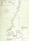
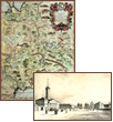
The map of the Kuril Islands and the surrounding lands.
France. 1788.
Copperplate engraving.
Rag paper.
58.5 x 85 cm.
Compiled on the base of the manuscript kept in the archive of the city of Okhotsk.
A page from La PerouseˇŻs travel
The map of the Eastern part of Asian Russia.
Italy, Rome, the Chamber cartography. 1796.
Copperplate engraving, watercolor.
Rag paper.
Off-print: 35 x 48 cm.
Sheet: 45 x 60 cm.
Engraver: S. Cassini
Moscow. Nikolskye Vorota.
Lithograph on pale-yellow background.
Image: 25 x 36 cm.
Sheet: 36 x 55 cm.
Author: Duran André;
Publisher: Bourdi Ernest
Printer: Brie August
France, Paris. The 40s of the 19th century.
1
|
2
|
3
|
4
|
5
|
6
| 7 |
8
|
9
Here you can order catalogue of exhibition
"
Maps and views of Russia. The exhibition of engravings and lithographs. 17th—19th centuries.
"
order catalogue
Great talent and unhappy life
>>>
Exhibition "A.P.Chekhov and the town of Voskresensk" in "New Jerusalem"
>>>
Enter your e-mail to subscribe to our news posting
Name
e-mail address
About the New Hermitage
|
News
|
Gallery's collections
|
Exhibitions in the New Hermitage
|
Publishing department
|
Library of images
|
Services of gallery
| |
Ďî-đóńńęč
© 2001 The New Hermitage
Design and support:
positive
media