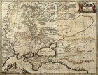
The map of the Tauric Chersonese with the Perekop Isthmus.
Holland, Amsterdam. 17th century.
Copperplate engraving, watercolor.
Rag paper.
Off-print: 38 x 50 cm.
Sheet: 49 x 59 cm.
Compiler: Massa Isaak
Engraver: Jansson Johann
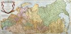
The map of Muscovy. Eastern part.
Italy. 17th century.
Copperplate engraving, watercolor.
Rag paper.
Off-print: 60 x 45.5 cm.
Sheet: 72 x 50 cm.
Compiler: Sardi Bartholomeo
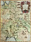
The map of European or Malaya Tatariya including Crimean Tatariya or Perekop, Nogay, Budgak, Ochakov.
France, Paris. 1665.
Copperplate engraving, watercolor.
Rag paper.
Off-print: 41.5 x 50 cm.
Sheet: 45 x 60 cm.
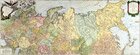
The map of the Russian Empire. European and Asian parts taken from the Atlas of Russia.
France, Paris. 1753.
Copperplate engraving, watercolor.
Rag paper.
Off-print: 47 x 119 cm.
Sheet: 51.5 x 130 cm.
Compiler: de Vagondi Rober
The third part of the map of Asia including Siberia and a part of Tatariya.
France, Paris. 1777.
Copperplate engraving, watercolor.
Rag paper.
Off-print: 107 x 53 cm.
Compiler: Danville
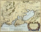
The map of the Black Sea and the surrounding regions.
France. The first half of the 18th century.
Copperplate engraving, watercolor.
Rag paper.
Off-print: 63.5 x 68 cm.
Sheet: 64 x 77 cm
1
|
2
|
3
|
4
| 5 |
6
|
7
|
8
|
9
Here you can order catalogue of exhibition
"
Maps and views of Russia. The exhibition of engravings and lithographs. 17th—19th centuries.
"
order catalogue
Great talent and unhappy life
>>>
Exhibition "A.P.Chekhov and the town of Voskresensk" in "New Jerusalem"
>>>
Enter your e-mail to subscribe to our news posting
Name
e-mail address
About the New Hermitage
|
News
|
Gallery's collections
|
Exhibitions in the New Hermitage
|
Publishing department
|
Library of images
|
Services of gallery
| |
Ďî-đóńńęč
© 2001 The New Hermitage
Design and support:
positive
media