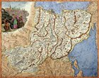
The map of the Malorossiysk guberniya (20 povets).
Russia. Late 18th century
Copperplate engraving, watercolor.
Rag paper, duplicated.
Off-print: 49 x 61 cm.
Sheet: 52 x 66 cm.
Compiler: Wilbrecht Alexander
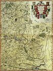
The map of the western part of the Irkutsk guberniya (15 uyezds).
Russia. Late 18th century.
Copperplate engraving, watercolor.
Rag paper, duplicated.
Off-print: 50 x 61 cm.
Sheet: 52 x 66 cm.
Compiler: Wilbrecht Alexander
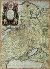
The map of the Perm guberniya (12 uyezds)
Russia. Late 18th century.
Copperplate engraving, watercolor.
Rag paper, duplicated.
Off-print: 51.5 x 66.5 cm.
Sheet: 59 x 66 cm.
Compiler: Wilbrecht Alexander
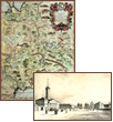
The map of the eastern part of Poland.
Italy. 17th century.
Copperplate engraving, watercolor.
Rag paper.
Off-print: 61 x 46 cm.
Sheet: 71.5 x 50 cm.
Compiler: Cornaro Federigo
The map of Lithuania.
Italy. 17th century.
Copperplate engraving, watercolor.
Rag paper.
Off-print: 45.5 x 61 cm.
Sheet: 49 x 72 cm.
Compiler: Kaiualldi Gianpiettro
The western part of the map including the Kingdom of Poland and a part of Muscovy.
Italy. 17th century.
Copperplate engraving, watercolor.
Rag paper.
Off-print: 45 x 61 cm.
Sheet: 50 x 72 cm.
Compiler: Sardi Bartholomeo
1
|
2
| 3 |
4
|
5
|
6
|
7
|
8
|
9
Here you can order catalogue of exhibition
"
Maps and views of Russia. The exhibition of engravings and lithographs. 17th—19th centuries.
"
order catalogue
Great talent and unhappy life
>>>
Exhibition "A.P.Chekhov and the town of Voskresensk" in "New Jerusalem"
>>>
Enter your e-mail to subscribe to our news posting
Name
e-mail address
About the New Hermitage
|
News
|
Gallery's collections
|
Exhibitions in the New Hermitage
|
Publishing department
|
Library of images
|
Services of gallery
| |
Ďî-đóńńęč
© 2001 The New Hermitage
Design and support:
positive
media